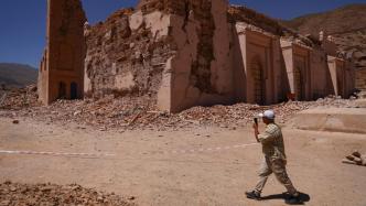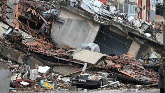
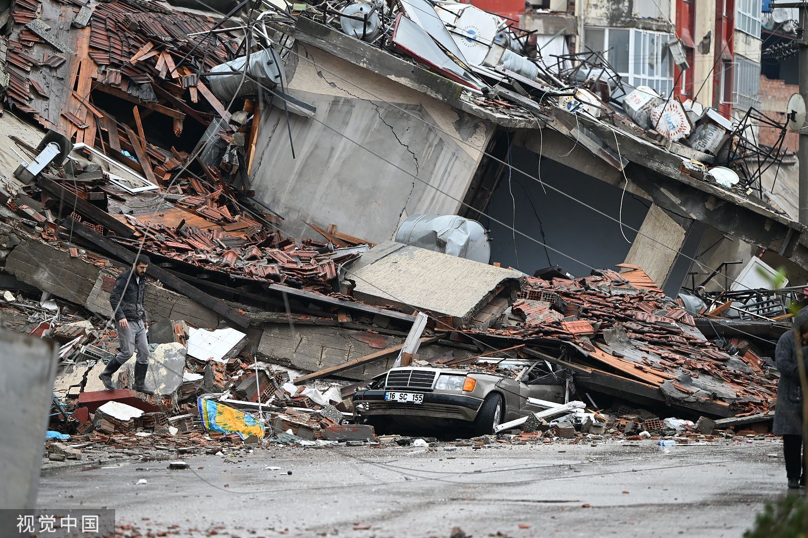
On February 6, 2023 local time, Hatay, Turkey, after a 7.8-magnitude earthquake hit Hatay, Turkey, the building was severely damaged.
According to the China Earthquake Network, at 4:28 local time on February 6 (9:28 Beijing time), a magnitude 7.8 earthquake occurred in Turkey. The epicenter was located in Kahramanmaras province in the south-central part of the country at a depth of 20 kilometers. The earthquake was felt throughout Asia, Africa and Europe, and also affected some neighboring countries.
On the same day, at 13:24 local time (18:24 Beijing time), another earthquake with a magnitude of 7.8 occurred near the previous earthquake.
These two earthquakes constitute a typical and rare "double shock" earthquake sequence.
According to the official microblog of China Earthquake Network Express, the 7.8-magnitude "double earthquake" in Turkey is the largest earthquake in the world this year. "The 'double earthquake' in Turkey is very rare, and the magnitude of the earthquake is comparable to that of the Wenchuan earthquake in my country." Xu Xiwei, the first president of the National Institute of Natural Disaster Prevention and professor of the School of Earth Sciences, China University of Geosciences (Beijing), was interviewed by China Science News explain. He also pointed out that the earthquake is located in the Himalayan-Mediterranean seismic belt related to China, and whether it will have a wider impact on seismic activities in this region needs to be strengthened to monitor and judge.
Turkey "sitting on the powder keg"
"China Science Daily": How do you view the destructive power of the world's largest earthquake this year?
Xu Xiwei: According to the measurement of the China Seismic Network, the energy released by the "double earthquake" in Turkey is equivalent to that of the Wenchuan earthquake in China.
"China Science Daily": What is the geological background of the Turkish earthquake?
Xu Xiwei: Turkey, a small country that spans two continents, is like "sitting on a powder keg", with 96% of its territory located on the earthquake zone. Turkey is located on the boundary of three major plates - the Arabian plate to the south wedges into Turkey, forming the Turkey-Iranian plateau; the African plate to the west pushes northwards to meet the Eurasian plate to the north. Due to the interaction between the plates, large earthquakes occur frequently.
There are two main left-lateral strike-slip fault zones in Turkey, namely the East Anatolia Fault Zone and the North Anatolia Fault Zone. The two fault zones meet in eastern Turkey. These two earthquakes occurred at the intersection of the southwestern end of the northeast-east Anatolian fault zone on the boundary between the Arabian plate and the Eurasian plate and the northern end of the near-north-south Dead Sea fault zone. The earthquake rupture length is expected to be about 300 kilometers.
The eastward extension of this seismic belt is the Himalayan seismic belt, and the westward extension is the Mediterranean seismic belt between the African plate and the Arabian plate, where earthquakes are also relatively concentrated. Turkey is located in the central and western part of this seismic belt.
This large earthquake belt is related to China
"China Science Daily": The Turkish earthquake is located on the Himalayan-Mediterranean earthquake belt. Will it have a further impact on the seismic activity in this area?
Xu Xiwei: In fact, this is a mid- to long-term earthquake prediction problem. In other words, whether the earthquake can reflect the interaction between several major plates, and judge whether the occurrence of the earthquake will have an impact on the central and eastern parts of the Himalayan-Mediterranean seismic belt, causing the Coulomb stress to increase, thereby triggering a major earthquake. Earthquake, that is, whether the seismic zone itself is already in a stage of concentrated release of seismic energy. But for every individual earthquake that occurs, it is difficult to accurately predict these days.
Both the East Anatolia Fault Zone and the North Anatolia Fault Zone are dominated by strike-slip earthquakes; the Eastern Himalayan Seismic Zone is dominated by thrust-type earthquakes, and the destructive intensity is often greater, so monitoring should be strengthened and judge.
"China Science Daily": When did the last major earthquake in Turkey occur, and what enlightenment does it have for related research?
Xu Xiwei: There have been many similar earthquakes in Turkey's history. The most recent major earthquake was the 7.4-magnitude earthquake that struck the city of Izmit in western Turkey on August 17, 1999, on the North Anatolia fault zone, killing 16,000 people.
That earthquake, together with the Nantou earthquake in Taiwan, China and the Hochtman earthquake in California, USA, constituted the three major earthquakes that year. Scientists at the three earthquake sites have found that the rupture of the earthquake fault has localized characteristics. The so-called earthquake rupture localization means that along the active fault where the earthquake occurs, a rupture zone with a width of tens of meters will be generated. The discovery of this local deformation feature provides a scientific basis and solution strategy for engineering fault resistance in the future. It shows that the width of engineering fault resistance is limited, which has attracted extensive attention from the earthquake engineering circles in various countries.
"China Science Daily": What is the significance of studying the earthquake in Turkey for disaster prevention and mitigation in China?
Xu Xiwei: The research on the localization characteristics of earthquake rupture is a scientific basis for the detection of urban active faults in China. Funded by the National Development and Reform Commission, we started to detect active faults in 20 provincial capital cities or cities under separate state planning in 2004, and have completed the work in nearly 100 cities. In layman's terms, it is to do a "physical examination" for the city, determine the location of active faults in the urban area, and try to keep important structures (buildings) away from these active faults in future urban planning, so as to avoid possible ruptures and damages, and prevent future problems. If not, truly implement the national disaster prevention strategy that puts prevention first.
We are drafting and compiling mandatory national standards for active fault avoidance, which are currently in the approval stage. This standard helps to avoid the damage of ground structures (buildings) caused by the dislocation of seismically active faults. At the same time, it is necessary to strictly implement the seismic fortification standards that can effectively reduce earthquake vibration damage.
Looking for an earthquake forecast "pointer" is on the way
"China Science Daily": After the earthquake, people are worried whether the world will enter an active period of relatively frequent large earthquakes. In terms of earthquake prediction and prediction, what are Chinese earthquake scientists doing?
Xu Xiwei: Earthquake prediction is difficult, but the China Earthquake Administration has been persisting and working hard to explore, and has made significant progress in determining the location of the earthquake, the method of magnitude, and the prediction effect. For example, the Second Monitoring Center of the China Earthquake Administration used images of positive and negative changes in surface gravity to make relatively good predictions for the Menyuan earthquake (magnitude 6.9) on January 8, 2022 and the Luding earthquake (magnitude 6.8) on September 5, 2022 . The National Institute of Natural Disaster Prevention and Control conducted continuous observations of deep hole stress at a depth of about one thousand meters near the intersection of three fault zones, including Longmenshan, Anning River, and Xianshui River, to monitor the stress state of active faults capable of causing major earthquakes. Discuss the intrinsic relationship between stress and earthquake occurrence. These developments have strengthened my confidence that stress measurements may be useful for earthquake monitoring and prediction, and may also be a breakthrough in earthquake prediction work.
Now, we have deployed multiple 1,000-meter-deep boreholes on both sides of the traffic corridor in the Xianshuihe fault zone for continuous observation. Fiber-optic strain gauges, fiber-optic seismometers and temperature monitors are densely installed in the borehole, trying to capture the clues of stress, temperature and microseismic changes before the earthquake, and understand whether the stress value and state can be used as a pointer for earthquake occurrence and prediction.
(Originally titled "Turkey's "Double Earthquake" Impact Still Needs Monitoring and Research")