The Surface Water and Ocean Topography (SWOT) satellite, developed jointly by NASA and the French National Center for Space Studies (CNES), is helping to improve tsunami forecast models, benefiting coastal communities.
At 11:25 a.m. local time on July 30, an 8.8 magnitude earthquake occurred off the coast of Kamchatka Peninsula, Russia, triggering a tsunami. SWOT recorded the tsunami about 70 minutes after the earthquake.
A tsunami occurs when a disturbance, such as an earthquake or underwater landslide, is large enough to displace a body of water from the seafloor to the surface. This causes waves to spread outward from the disturbance, much like a pebble dropped into a pond creates a series of ripples.

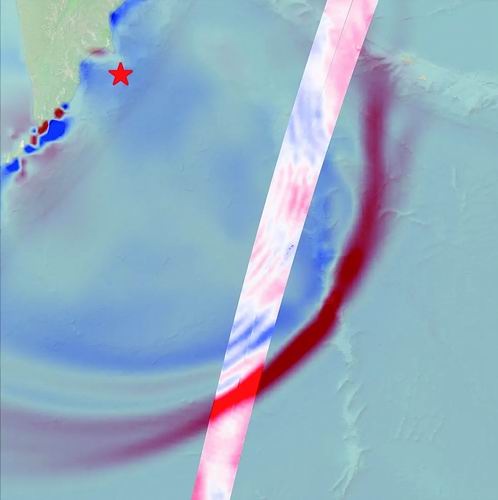
SWOT captured this image of a tsunami wave front sweeping across the Pacific Ocean on July 30. Image credit: NASA/JPL-Caltech
“SWOT’s extensive ocean scanning is designed to provide critical, real-world data, reveal new laws of physics, and move toward more accurate early warnings and a safer future,” said Nadya Vinogradova Shiffer, NASA Earth Science lead and SWOT project scientist.
In this case, SWOT data provided a multi-dimensional view of the tsunami front generated by the Kamchatka earthquake. Measurements included wave heights exceeding 1.5 feet (45 centimeters), highlighted in red, as well as the shape and direction of the tsunami front. The SWOT data, highlighted in the visual image extending from southwest to northeast, was compared with a tsunami forecast model developed by the National Oceanic and Atmospheric Administration (NOAA) Tsunami Research Center. Comparing the two helped forecasters validate the model and ensure its accuracy.
"A 1.5-foot wave might not seem like much, but a wave of one or two feet high in the open ocean can become a 30-foot wave in shallow coastal waters," said Ben Hamlington of NASA's Jet Propulsion Laboratory.
Tsunami measurements collected by SWOT are helping scientists at the NOAA Tsunami Research Center refine their tsunami forecasting model. The model uses a range of earthquake-tsunami scenarios based on historical observations and real-time data from ocean sensors. Based on the model's output, NOAA issues warnings to coastal communities that may be in the tsunami's path.
The data SWOT collects on tsunami wave height, shape, and propagation direction is key to improving these forecast models. Josh Willis of NASA's Jet Propulsion Laboratory said, "Satellite observations help researchers better infer the causes of tsunamis, and in this case, the observations also show that NOAA's tsunami forecasts were very accurate."
Vasily Titov, chief scientist at NOAA's Tsunami Research Center, said the center tested the model using SWOT's tsunami data and the results were encouraging. "This shows that SWOT data has the potential to significantly improve operational tsunami forecasting, which has been sought since the 2004 Sumatra tsunami," he said. That devastating earthquake triggered a tsunami that killed thousands of people and caused widespread damage in Indonesia.
(Original title: US-France SWOT satellite captures astonishing details of Kamchatka earthquake and tsunami)
- jezfUXZX08/20/2025
- hvAEGnclxWpDSo08/20/2025
- ZiLZRlMMvSSvo08/19/2025